Earth and related Environmental SciencesQuarto

Thinking in spatial patterns

Hi! I’m Jakub Nowosad, an Associate Professor at Adam Mickiewicz University and a Visiting Scientist at the University of Münster. My work focuses on developing spatial methods to better understand environmental processes. Here, I present my research, publications, and geocomputational projects.
Home PageRSS Feed
language
BookGeocomprRstatsSpatialVisEarth and related Environmental Sciences
Published

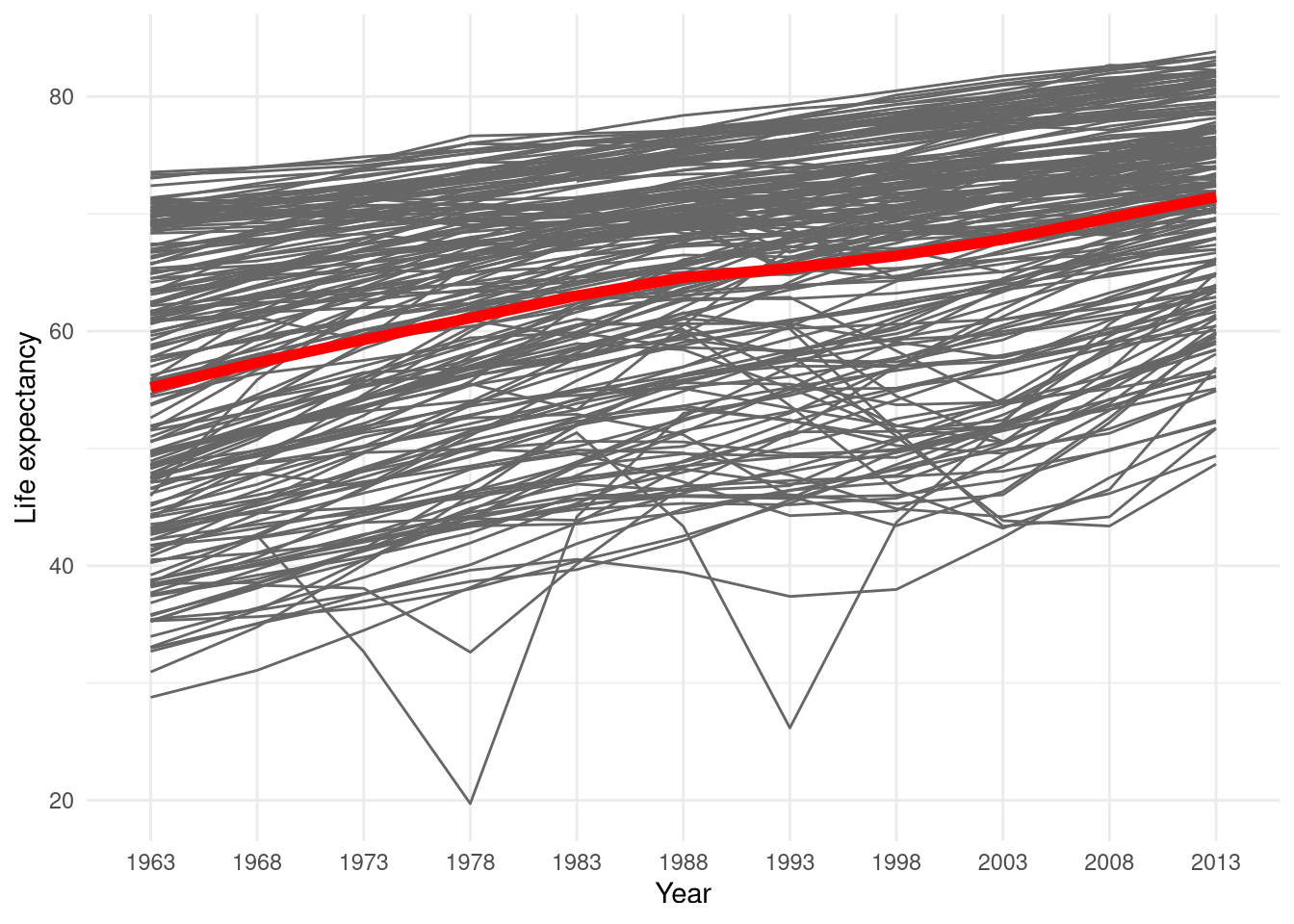
Global socio-economic data is easily accessible nowadays. Just type the indicator of interest and the name of the country in your preferred search engine and you can find its value, sometimes also an additional plot or a map. But what about when you want to go further and (for example): Want to compare many countries? Get data just for a specific year? See changes in time? Just want to create a very specific plot or a map?

SpatialPatternSpatiotemporalGeopatSilEarth and related Environmental Sciences
Published

Blog posts in the series introducing GeoPAT 2 - a software for pattern-based spatial and temporal analysis: GeoPAT 2: Software for Pattern-Based Spatial and Temporal Analysis Pattern-based Spatial Analysis - core ideas Finding similar local landscapes Quantifying temporal change of landscape pattern Pattern-based regionalization Moving beyond pattern-based analysis: Additional applications of GeoPAT 2 Take a look at the satellite image below -

BookGeocomprRstatsSpatialVisEarth and related Environmental Sciences
Published

Update (2018-12-12): Alternative approach to this problem can be found at https://github.com/Nowosad/us-map-alternative-layout. Introduction Maps of United States often focus only on the contiguous 48 states. In many maps Alaska and Hawaii are simply not shown or are displayed at different geographic scales than the main map.

BookGeocomprRstatsSpatialEarth and related Environmental Sciences
Published

Hello everybody! A lot of things have changed since the last blogpost about Geocomputation with R. In this post I’ll give an update of our progress and our plans for the next chapters. Third author Probably the most important change is having a third author - Jannes Muenchow. He is a GIScientist based at the University of Jena with a keen interest in spatial and geostatistical modeling, algorithm automation and geocomputation.

BookGeocomprRstatsSpatialEarth and related Environmental Sciences
Published

Just over one year ago, I met Robin in Poznan, Poland, who was teaching as part of the GEOCENTRUM project at the Adam Mickiewicz University. To our surprise, we found that we shared an idea of writing a book explaining how to use R for spatial data analysis. The timing worked well.

RstatsWorkshopSpatialVisualizationProcessingEarth and related Environmental Sciences
Published

Last week, I had a pleasure to conduct a workshop for graduate students and faculty in the Department of Geography and GIS at the University of Cincinnati.