Published in Front Matter

On Tuesday the journal PLOS ONE celebrated its 10th anniversary (see blog post by PLOS ONE Editor-in-Chief Jörg Heber and blog post by PLOS ONE Managing Editor Iratxe Puebla and PLOS Advocacy Director Catriona MacCallum). PLOS ONE (and PLOS) have changed scholarly publishing in many ways, from a DataCite perspective probably most importantly via the data policy updated in February 2014 that states that PLOS ONE was not the first journal with a

References

Space and Planetary ScienceEarth and Planetary Sciences (miscellaneous)Geochemistry and PetrologyGeophysics

Field investigation of dried lakes in western United States as an analogue to desiccation fractures on Mars

Published in Journal of Geophysical Research: Planets
Authors M. R. El‐Maarry, W. A. Watters, Z. Yoldi, A. Pommerol, D. Fischer, U. Eggenberger, N. Thomas

AbstractPotential Desiccation Polygons (PDPs), tens to hundreds of meters in size, have been observed in numerous regions on Mars, particularly in ancient (>3 Gyr old) terrains of inferred paleolacustrine/playa geologic setting, and in association with hydrous minerals such as smectites. Therefore, a better understanding of the conditions in which large desiccation polygons form could yield unique insight into the ancient climate on Mars. Many dried lakebeds/playas in western United States display large (>50 m wide) desiccation polygons, which we consider to be analogues for PDPs on Mars. Therefore, we have carried out fieldwork in seven of these dried lakes in San Bernardino and the Death Valley National Park regions complemented with laboratory and spectral analysis of collected samples. Our study shows that the investigated lacustrine/playa sediments have (a) a soil matrix containing ~40–75% clays and fine silt (by volume) where the clay minerals are dominated by illite/muscovite followed by smectite, (b) carbonaceous mineralogy with variable amounts of chloride and sulfate salts, and significantly, (c) roughly similar spectral signatures in the visible‐near‐infrared (VIS‐NIR) range. We conclude that the development of large desiccation fractures is consistent with water table retreat. In addition, the comparison of the mineralogical to the spectral observations further suggests that remote sensing VIS‐NIR spectroscopy has its limitations for detailed characterization of lacustrine/playa deposits. Finally, our results imply that the widespread distribution of PDPs on Mars indicates global or regional climatic transitions from wet conditions to more arid ones making them important candidate sites for future in situ missions.

Earth and Planetary Sciences (miscellaneous)Earth-Surface ProcessesGeography, Planning and Development

Sedimentary effects of flood‐producing windstorms in playa lakes and their role in the movement of large rocks

Published in Earth Surface Processes and Landforms
Authors M. E. Sanz‐Montero, Ó. Cabestrero, J. P. Rodríguez‐Aranda

AbstractThis paper sheds light on the hydrodynamic conditions of transport and sedimentary effects of wind‐induced water currents produced during strong windstorms in low gradient systems. Repeated field surveys were conducted in a playa lake in central Spain to determine the impacts of major winter storms on the bed form morphology in real time. The succession of storms that passed through the area from mid‐December 2013 to early February 2014 left behind a variety of sedimentary structures: mainly ripple marks showing complex patterns and erosional structures. The latter include obstacle scours, grooves and other tool marks. In situ observations revealed that strong storm events in almost flat, extremely shallow lakes (less than 5 cm) have enough hydraulic energy to erode and remove high volumes of sediments and may also lead to large stones sliding across the bed, thus creating long grooves.Sole marks found in ancient continental successions have been typically attributed to fluvial conditions. We suggest that shallow lake basins should not be discounted when storm‐generated structures are preserved in ancient rocks. The identification of such sedimentary structures provides valuable information for reconstructing hydrodynamic conditions and paleoclimatic conditions in semi‐arid environments. Copyright © 2014 John Wiley & Sons, Ltd.

Physics Education (physics.ed-ph)Popular Physics (physics.pop-ph)Physics and Society (physics.soc-ph)FOS: Physical sciencesFOS: Physical sciences

Exposición Temprana de Nativos Digitales en Ambientes, Metodologías y Técnicas de Investigación en la Universidad

Published
Authors H. Asorey, L. A. Nunez, C. Sarmiento-Cano

Being aware of the motivation problems observed in many scientific oriented careers, we present two experiences to expose to college students to environments, methodologies and discovery techniques addressing contemporary problems. This experiences are developed in two complementary contexts: an Introductory Physics course, where we motivated to physics students to participate in research activities, and a multidisciplinary hotbed of research oriented to advanced undergraduate students of Science and Engineering (that even produced three poster presentations in international conferences). Although these are preliminary results and require additional editions to get statistical significance, we consider they are encouraging results. On both contexts we observe an increase in the students motivation to orient their careers with emphasizing on research. In this work, besides the contextualization support for these experiences, we describe six specific activities to link our students to research areas, which we believe can be replicated on similar environments in other educational institutions.

Physical: Landscape Evolution: modelling and field studies

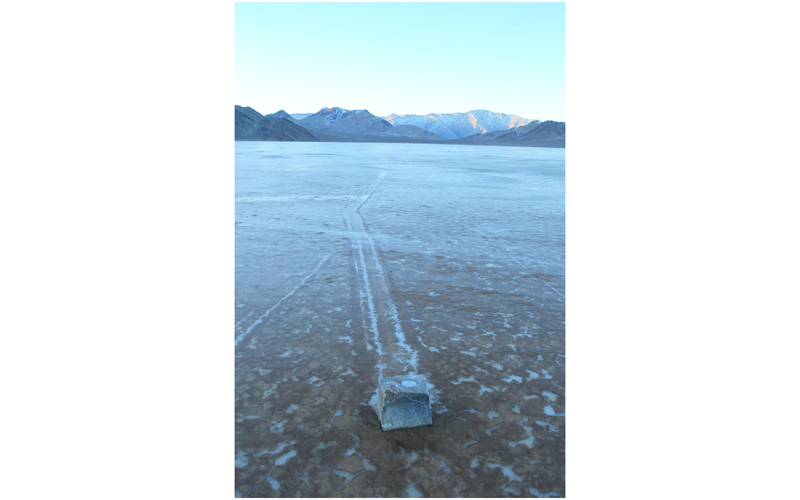
Trail formation by ice-shoved "sailing stones" observed at Racetrack Playa, Death Valley National Park

Published
Authors R. D. Lorenz, J. M. Norris, B. K. Jackson, R. D. Norris, J. W. Chadbourne, J. Ray

Abstract. Trails in the usually-hard mud of Racetrack Playa in Death Valley National Park attest to the seemingly-improbable movement of massive rocks on an exceptionally flat surface. The movement of these rocks, previously described as "sliding stones", "playa scrapers", "sailing stones" etc., has been the subject of speculation for almost a century but is an exceptionally rare phenomenon and until now has not been directly observed. Here we report documentation of multiple rock movement and trail formation events in the winter of 2013–2014 by in situ observation, video, timelapse cameras, a dedicated meteorological station and GPS tracking of instrumented rocks. Movement involved dozens of rocks, forming fresh trails typically of 10s of meters length at speeds of ~5 cm s−1 and were caused by wind stress on a transient thin layer of floating ice. Fracture and local thinning of the ice decouples some rocks from the ice movement, such that only a subset of rocks move in a given event.